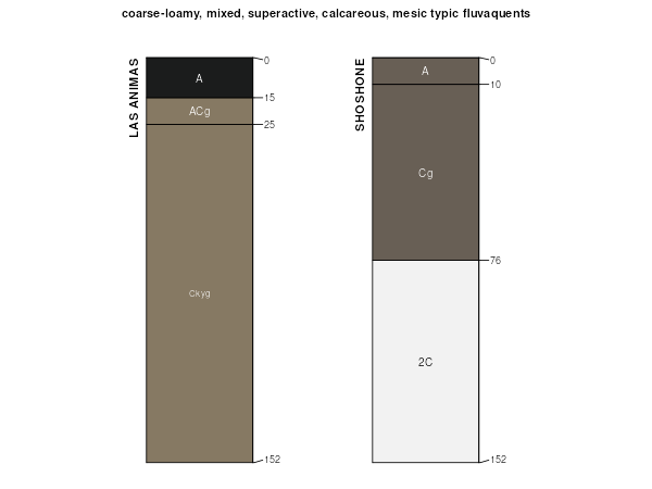
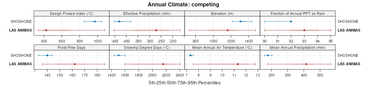
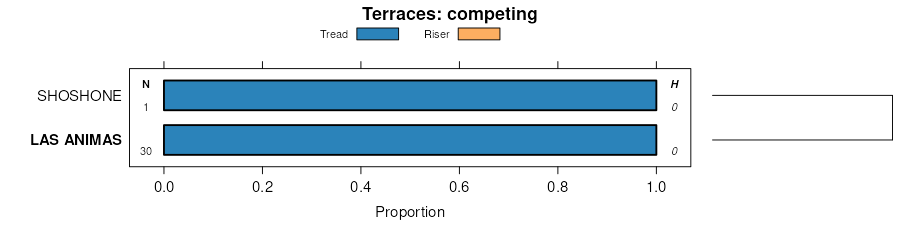
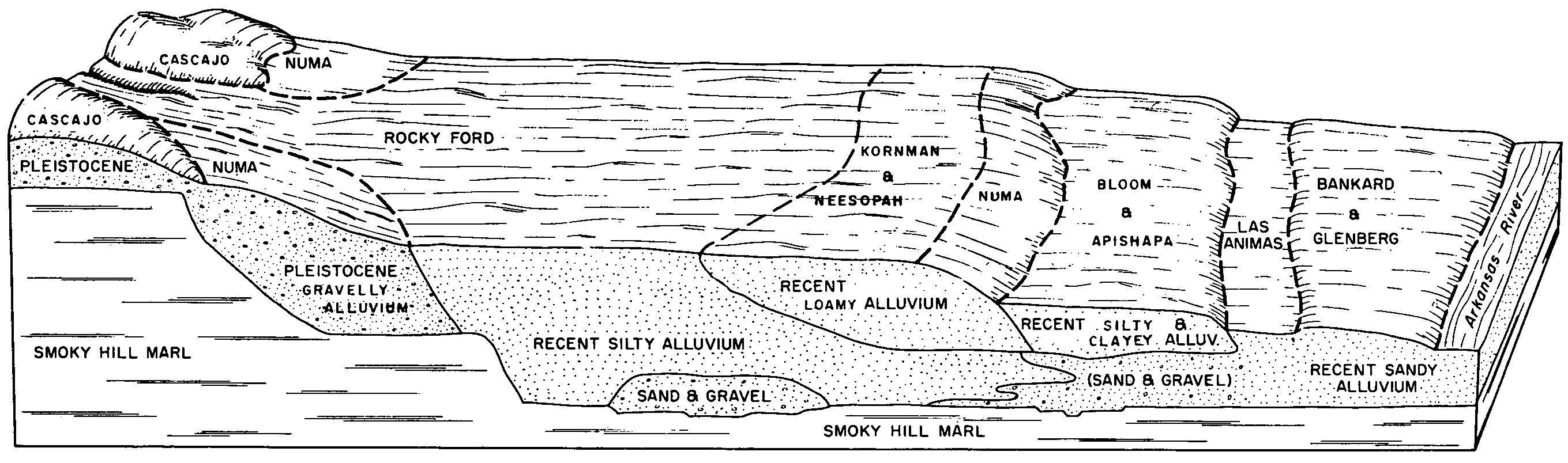
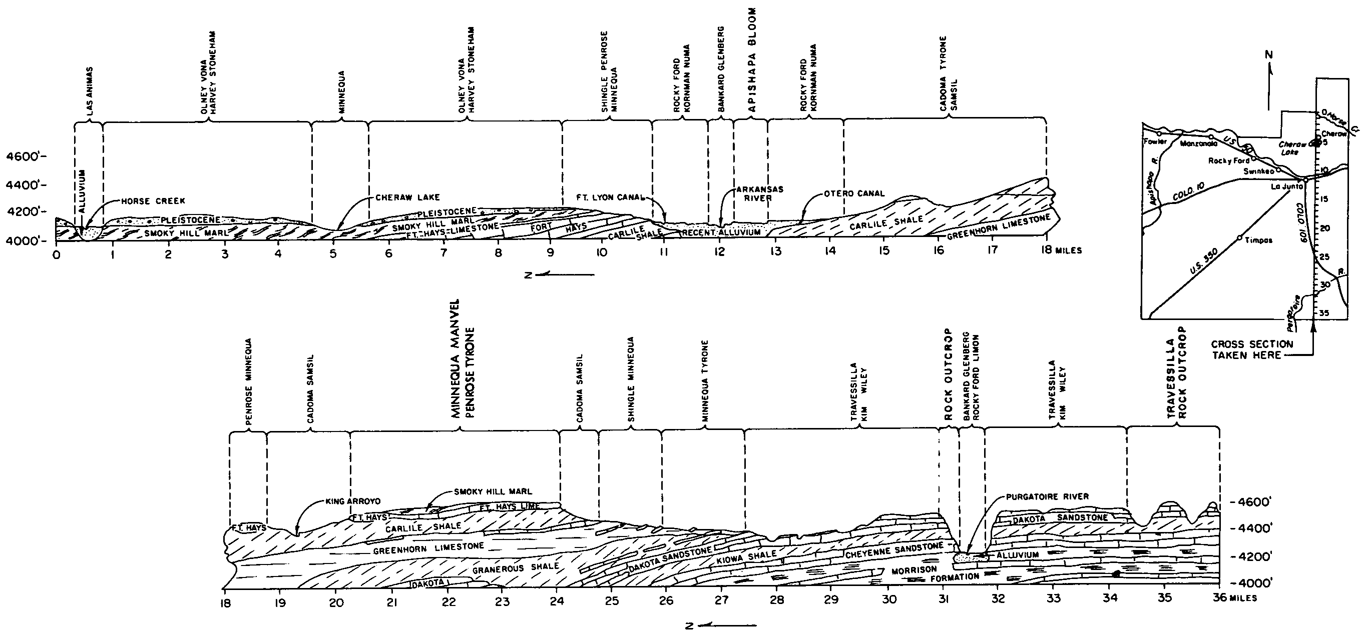
| Las Animas loam, 0 to 1 percent slopes, occasionally flooded | Lm | 1718 | 94254 | 2yz49 | co011 | 1965 | 1:15840 |
Las Animas sandy loam, 0 to 2 percent slopes, occasionally flooded | Lm | 1365 | 94368 | 2yz42 | co025 | 1965 | 1:15840 |
Las Animas sandy loam, 0 to 3 percent slopes, occasionally flooded | 145 | 2517 | 105226 | 3jhd | co073 | 2001 | 1:24000 |
Las Animas silty clay, 0 to 3 percent slopes, occasionally flooded | Lm | 2989 | 94733 | 2xyrh | co089 | 1966 | 1:15840 |
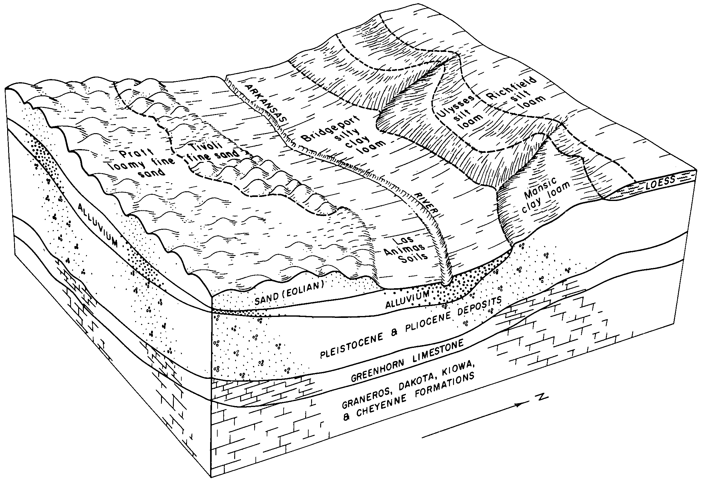
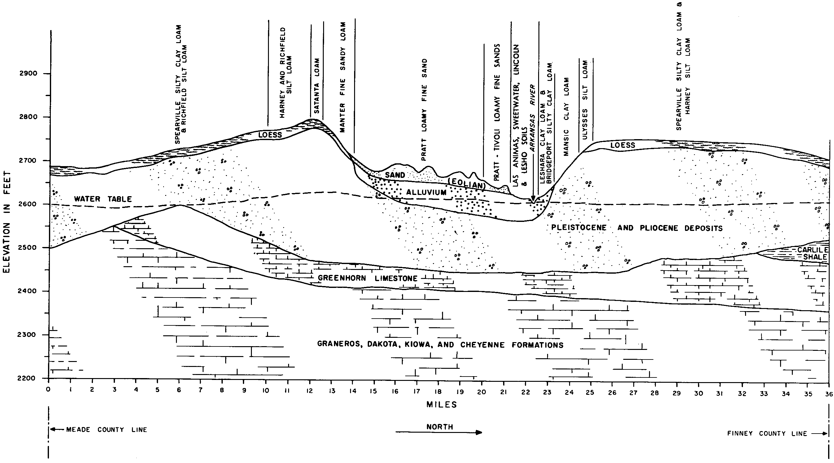
Las Animas soils | Lt | 3138 | 94845 | 35pj | co099 | 1963 | 1:15840 |
Las Animas fine sandy loam | 27 | 4315 | 95070 | 35xs | co125 | 1976 | 1:24000 |
Las Animas loam | 28 | 1862 | 95071 | 35xt | co125 | 1976 | 1:24000 |
Las Animas fine sandy loam, 0 to 2 percent slopes, frequently flooded | Lm | 9753 | 95502 | 2xyrg | co626 | 1974 | 1:24000 |
Ellicott-Las Animas complex, 0 to 2 percent slopes, occasionally flooded | EL | 2612 | 2484276 | 2pd2y | co627 | 1980 | 1:24000 |
Riverwash-Las Animas complex | 72 | 1421 | 496512 | jnnj | co627 | 1980 | 1:24000 |
Ellicott-Las Animas complex, 0 to 2 percent slopes, occasionally flooded | EL | 4580 | 2499251 | 2pd2y | co628 | 2008 | 1:24000 |
Las Animas loam, 0 to 1 percent slopes | Ls | 197 | 105349 | 3jmc | co628 | 2008 | 1:24000 |
Las Animas loam, occasionally flooded | 1182 | 4617 | 1149551 | 17l69 | ks023 | 1987 | 1:24000 |
Las Animas loamy fine sand, occasionally flooded | 1183 | 837 | 1380373 | 2zt6n | ks047 | 1967 | 1:24000 |
Las Animas-Lincoln complex, occasionally flooded | 1187 | 32 | 1380375 | 2zt78 | ks047 | 1967 | 1:24000 |
Las Animas sandy loam, occasionally flooded | 1185 | 1 | 1380374 | 2zt77 | ks047 | 1967 | 1:24000 |
Las-Las Animas complex, occasionally flooded | 1235 | 4387 | 1152316 | 17p2h | ks055 | 1962 | 1:24000 |
Las Animas-Lincoln loamy sands, occasionally flooded | 1188 | 4216 | 1152312 | 17p2c | ks055 | 1962 | 1:24000 |
Las Animas sandy loam, occasionally flooded | 1185 | 1938 | 1152310 | 2zt77 | ks055 | 1962 | 1:24000 |
Las Animas soils, occasionally flooded | 1190 | 47 | 1152311 | 17p2b | ks055 | 1962 | 1:24000 |
Las Animas loamy sand, occasionally flooded | 1184 | 45 | 1152309 | 17p28 | ks055 | 1962 | 1:24000 |
Las Animas-Lincoln complex, occasionally flooded | 1187 | 6546 | 1380437 | 2zt78 | ks057 | 1962 | 1:24000 |
Las Animas sandy loam, occasionally flooded | 1185 | 2824 | 1380435 | 2zt77 | ks057 | 1962 | 1:24000 |
Las Animas-Tivoli complex, 0 to 6 percent slopes, occasionally flooded | 1189 | 1194 | 1380438 | 1hbg8 | ks057 | 1962 | 1:24000 |
Las Animas-Lesho complex, alkali, occasionally flooded | 1186 | 388 | 1380436 | 1hbg6 | ks057 | 1962 | 1:24000 |
Lesho, saline-Las Animas complex, occasionally flooded | 2155 | 1787 | 1380662 | 1hbph | ks067 | 1965 | 1:24000 |
Las Animas soils, occasionally flooded | 1190 | 4170 | 1380569 | 1hblh | ks069 | 1965 | 1:24000 |
Las Animas-Lesho complex, alkali, occasionally flooded | 1186 | 3248 | 1380570 | 1hblj | ks069 | 1965 | 1:24000 |
Las Animas sandy loam, occasionally flooded | 1185 | 973 | 1380568 | 2zt77 | ks069 | 1965 | 1:24000 |
Las-Las Animas complex, occasionally flooded | 1235 | 9 | 1380572 | 1hbll | ks069 | 1965 | 1:24000 |
Las Animas loamy sand, occasionally flooded | 1184 | 3314 | 1152218 | 17nzb | ks075 | 1959 | 1:24000 |
Las Animas sandy loam, occasionally flooded | 1185 | 2780 | 1152219 | 2zt77 | ks075 | 1959 | 1:24000 |
Las variant-Las Animas complex, occasionally flooded | 1233 | 364 | 1152225 | 17nzk | ks075 | 1959 | 1:24000 |
Las Animas loamy sand, occasionally flooded | 1184 | 3713 | 1152265 | 17p0v | ks093 | 1961 | 1:24000 |
Las Animas sandy loam, occasionally flooded | 1185 | 2617 | 1152266 | 2zt77 | ks093 | 1961 | 1:24000 |
Las-Las Animas complex, occasionally flooded | 1235 | 2101 | 1152270 | 17p10 | ks093 | 1961 | 1:24000 |
Las Animas sandy loam, occasionally flooded | 1185 | 2078 | 1150525 | 2zt77 | ks109 | 1962 | 1:24000 |
Las Animas sandy loam, occasionally flooded | 1185 | 2663 | 1382620 | 1hdqn | ks175 | 1963 | 1:24000 |
Las Animas-Lisco very fine sandy loams, occasionally flooded | 1189 | 2936 | 357806 | d0b4 | ne013 | 1980 | 1:20000 |
Las Animas-Lisco complex, occasionally flooded | 1188 | 1050 | 2217448 | 2dffl | ne013 | 1980 | 1:20000 |
Las Animas loam, frequently flooded | 1184 | 705 | 1698695 | 1v0mm | ne033 | 1989 | 1:20000 |
Las Animas loam, channeled, frequently flooded | 1183 | 186 | 2219695 | 2dhs2 | ne033 | 1989 | 1:20000 |
Las Animas soils, 0 to 2 percent slopes | 1187 | 1815 | 358124 | d0nd | ne045 | 1973 | 1:20000 |
Las Animas loam, channeled, frequently flooded | 1183 | 1359 | 1698813 | 1v0rf | ne049 | 2000 | 1:24000 |
Las Animas loam, occasionally flooded | 1182 | 467 | 1698814 | 1v0rg | ne049 | 2000 | 1:24000 |
Las Animas loam, channeled, occasionally flooded | 1186 | 1811 | 1692549 | 1tt7c | ne105 | 2004 | 1:24000 |
Las Animas loam, occasionally flooded | 1182 | 1393 | 1699462 | 1v1fc | ne145 | 1965 | 1:20000 |
Las Animas sand, occasionally flooded | 1198 | 148 | 1699435 | 1v1dh | ne145 | 1965 | 1:20000 |
Las Animas fine sandy loam, occasionally flooded | 1180 | 3130 | 1653756 | 1shvz | ne157 | 1965 | 1:20000 |
Las Animas loam, occasionally flooded | 1182 | 594 | 1653757 | 1shw0 | ne157 | 1965 | 1:20000 |
Las Animas fine sandy loam, channeled, frequently flooded | 1181 | 3 | 2227659 | 2ds1z | ne157 | 1965 | 1:20000 |
Las Animas loam, occasionally flooded | 1182 | 578 | 100610 | 3cph | ne161 | 1992 | 1:20000 |
Las Animas-Lisco complex, occasionally flooded | 1188 | 5498 | 357933 | d0g7 | ne165 | 1993 | 1:20000 |
Las Animas fine sandy loam, occasionally flooded | 1180 | 2284 | 357931 | 2zj4p | ne165 | 1993 | 1:20000 |
Las Animas fine sandy loam, channeled, frequently flooded | 1181 | 604 | 357932 | 2zj4q | ne165 | 1993 | 1:20000 |
Las Animas fine sandy loam, 0 to 2 percent slopes | 155 | 42 | 349624 | cqt6 | wy027 | 1993 | 1:24000 |
Baroid-Las Animas variant sandy loams | 8 | 2255 | 152128 | 539c | wy043 | 1976 | 1:24000 |
Baroid-Las Animas complex, wet, 0 to 3 percent slopes -- Draft | 509A | 6281 | 152241 | 53f0 | wy603 | | 1:24000 |
Las Animas-Lisco complex, 0 to 2 percent slopes, occasionally flooded | 92 | 286 | 1415378 | 1jhtc | wy715 | 1974 | 1:20000 |
Las Animas fine sandy loam, channeled, 0 to 2 percent slopes | 93 | 27 | 1415379 | 1jhtd | wy715 | 1974 | 1:20000 |

